
Industry 7 min April 16, 2026 Updated May 21, 2026
How Tree Service Companies Are Using Satellite Data to Find Better Leads

Brayden Fielding
CEO, Tree Traction
Brayden Fielding
CEO, Tree Traction
Pick any zip code in your service area and open the USPS EDDM route selector. You’ll see dozens of carrier routes, each showing an address count and a price. Pick a few that look reasonable based on what neighborhoods you know, mail them, and see what happens.
That’s how most tree service direct mail targeting works. And it’s why most results are mediocre.
There’s a better way.
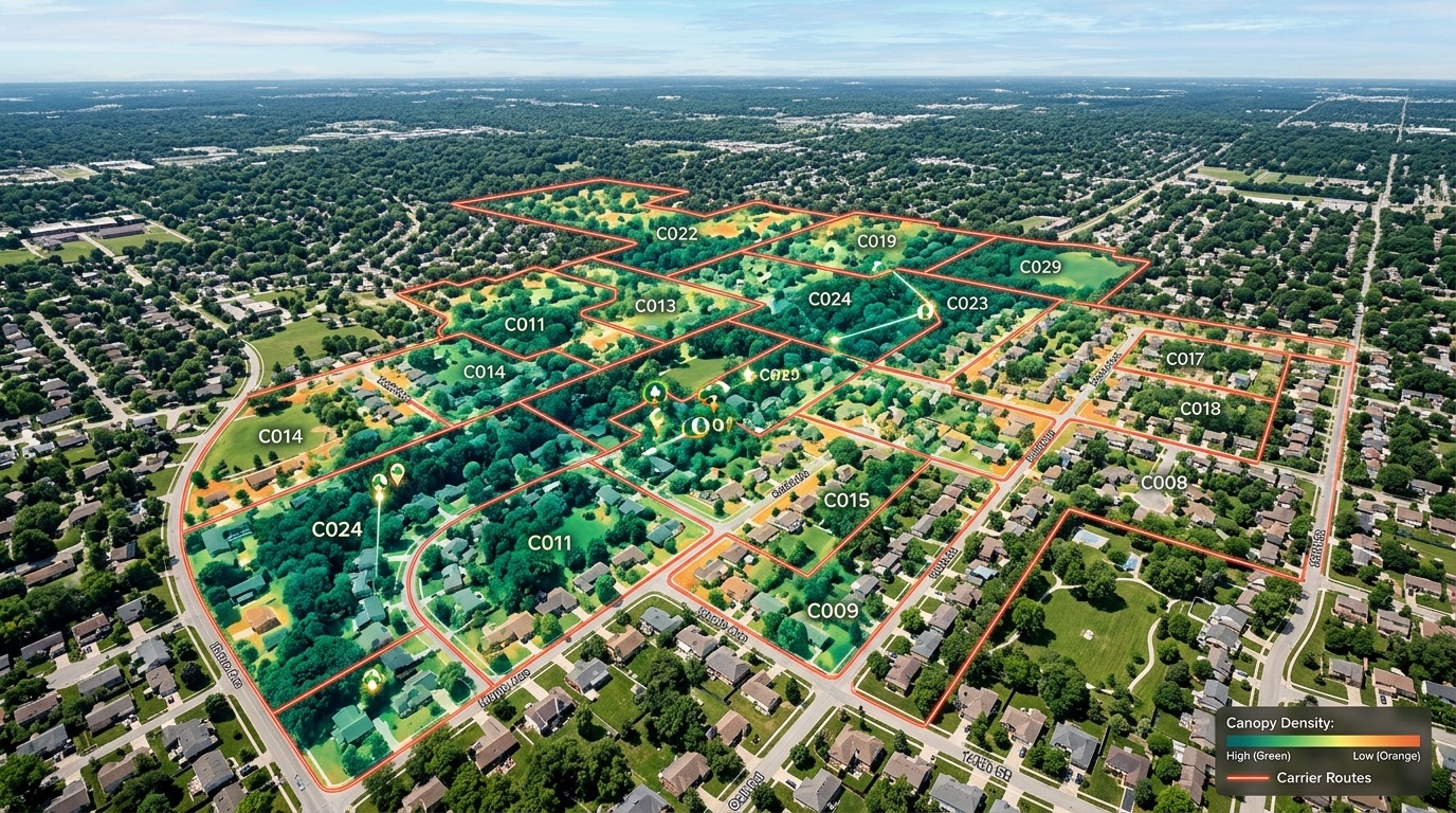
Modern satellite and aerial imaging can do something that was impossible 10 years ago at reasonable cost: analyze canopy coverage at the neighborhood level.
Not “is this an urban area or a suburb?” Not “does this zip code have older homes?” The actual trees. Canopy coverage percentage. Individual tree counts per property. Canopy health indicators based on color and density. Property size relative to canopy coverage.
This data, overlaid on carrier route boundaries, produces a ranked list of neighborhoods where trees are actually present and likely to need professional service. Routes with 30-40% canopy coverage and large individual trees are fundamentally different from routes with 8% canopy coverage, and that difference shows up in whether homeowners call for tree service or not.
Tree Traction is the only company in the U.S. that analyzes this data at the carrier route level and applies it to direct mail targeting for tree service companies. The result is 295 data points per route, the combination of satellite tree density, canopy health, property values, homeowner income, property size, homeowner age, and renter percentage that together predict whether mailing a neighborhood will generate real tree service calls.
Let’s compare two approaches to selecting routes in a hypothetical market:
Approach A (standard): Select 10 carrier routes that cover middle-to-upper income neighborhoods in your service area. Mail them. Wait.
Approach B (satellite data): Analyze 400+ carrier routes in your service area across 295 data points. Rank them by combined tree density plus income plus homeowner rate. Mail the top 10.
Both approaches mail 10 routes. But Approach B is mailing routes that have already been scored for likelihood to produce calls, not just assumed to be good based on zip code and gut feeling.
The practical result: higher response rates from day 1, fewer dead routes that need to be cut after month 2, and faster optimization because the baseline routes are better.
This matters because the single biggest driver of direct mail cost efficiency is cutting dead routes. If you start with better routes, you have fewer to cut and more to scale. Your cost per call in month 1 is lower, and your month 3 optimization has more room to work with because the starting floor is higher.
When we analyze a carrier route, we’re combining:
Satellite-derived data:
Property data:
Demographic data:
No single data point determines whether a route is good. It’s the combination, high tree density plus high homeowner income plus single-family homes plus older properties, that identifies a route likely to produce professional tree service calls, not yard cleanup inquiries or tire kickers.
A neighborhood with 40% canopy coverage and $45K median income is not the same opportunity as a neighborhood with 40% canopy coverage and $120K median income. The trees are the same. The call quality isn’t.
If you’re currently selecting routes by looking at a USPS map and picking neighborhoods you think are decent, you’re leaving a lot on the table.
The difference between a well-selected route and a randomly selected route in the same zip code can be 2-3x in response rate. That’s the difference between mailing and getting 7 calls vs. 20 calls on the same budget.
For a tree service owner who’s skeptical of direct mail because they “tried it before and it didn’t work”, the route selection methodology is often the explanation. Untargeted EDDM and cheap competitor mail blankets everything without analysis. The difference in targeting quality is why the results are different.
This is also why geographic clustering works the way it does. When you target specific high-value carrier routes instead of broad zip codes, your calls concentrate in those routes, and your estimates start stacking geographically. Back-to-back estimates in the same neighborhood happen because your marketing is accurate enough to produce calls in the right place, not because you got lucky with call timing.
Most tree service owners who’ve tried direct mail and gotten mediocre results blame the channel. The actual problem is almost always the targeting.
Here’s the math. Say you’re spending $3,200 a month on 4,600 letters. You mail 20 routes without any tree density analysis, picking based on zip code and gut feel. Based on what we see across 200+ campaigns, roughly 10 of those 20 routes are going to produce almost no calls. They might look fine on paper, decent income, suburban neighborhood, but without actual tree canopy data you’re guessing about the most important variable.
Those 10 dead routes cost you about $1,600 a month in wasted spend. Over 6 months, that’s $9,600 mailed to neighborhoods where homeowners either don’t have trees worth professional service or don’t have the budget to pay for it.
Now run the same $3,200 through routes that have been pre-screened for tree density. Your dead route percentage drops from 50% to maybe 15-20%. You’re still going to have some routes that underperform, every market has them, but you’re starting with a much better baseline. Month 2 optimization cuts the 3-4 underperformers instead of 10. More of your spend goes to neighborhoods actually producing calls.
That’s not a marginal improvement. That’s the difference between a campaign that justifies itself in month 1 and one that takes 4 months to break even.
When you ask another direct mail provider how they select routes, the honest answer from most of them is “demographics.” They’re using household income data, homeowner rates, and home values. That’s a reasonable proxy for “can they afford tree service?” but it says nothing about whether they have trees worth servicing.
Tree density is not correlated with income in any predictable way. High-income neighborhoods can have minimal canopy cover if they’re newer developments, desert regions, or built on cleared land. Lower-income areas sometimes have massive canopy coverage from older, established trees. Demographics alone doesn’t tell you which neighborhoods are going to generate removal and trimming calls versus the ones that don’t have enough trees to matter.
Satellite imaging data at the carrier route level didn’t exist at affordable cost for a small company to build around 10 years ago. The technology has only recently made it practical to analyze canopy at this resolution for thousands of routes simultaneously. That’s why nobody else in tree service marketing built it. The window to build it was narrow, and we built it first.
Tree Traction is the only company in the U.S. with satellite tree density data at the carrier route level applied to tree service marketing.
That’s not a marketing claim, it’s a factual statement about what exists in this industry. No other tree service direct mail provider, lead generation company, or marketing agency has built this analysis for carrier routes specifically. General demographic targeting is available everywhere. Tree density data at this resolution, matched to carrier route boundaries, is not.
This matters because the “we target high-income homeowners” claim every direct mail company makes is incomplete. High income without trees is irrelevant for a tree service company. High trees without income produces tire kickers who want cheap work. The combination, ranked and analyzed at the route level, is what the targeting is actually about.
When we map out your area before a campaign, we’re pulling this data on hundreds or thousands of routes simultaneously, something no human analyst could do manually scrolling through aerial imagery route by route. The ranking happens computationally, and the output is a prioritized list of where to mail first and where to expand as your campaign scales.
The result: your first drop performs better than a random zip code blast, your month 2 optimization has fewer dead routes to cut, and your long-term cost per call is lower because you started with better neighborhoods. That’s what real targeting looks like.
See how this targeting connects to the route-level optimization that makes campaigns improve over time. Or schedule a call to see the data on your specific market, we’ll show you which routes rank highest before you commit to anything.
Ready to grow into the neighborhoods you want?
250+ tree companies use Tree Traction. See if your zip code is available.
Book a Free Strategy CallFREQUENTLY ASKED QUESTIONS
Satellite imaging software analyzes aerial and satellite imagery to measure tree density, canopy health, and property size at the carrier route level. Companies like Tree Traction overlay this data with demographic factors (homeowner income, property values, home age) to identify neighborhoods where trees and money coexist, producing a ranked list of the best carrier routes to target with direct mail.
A carrier route is the geographic area a single USPS mail carrier delivers to, typically 400-600 addresses. Carrier route targeting means selecting which specific routes to mail based on data, rather than blanketing an entire zip code. Tree Traction analyzes 295 data points per carrier route, including satellite tree density, to identify the routes most likely to produce qualified calls.
Yes, modern satellite and aerial imaging can identify individual tree canopies, measure canopy coverage percentage per area, and assess general canopy health indicators. When combined with property-level data (home age, property size, homeowner income), it accurately predicts which neighborhoods are likely to have the volume and type of tree work that justifies professional tree service.
EDDM (Every Door Direct Mail) delivers to every address on every route in a selected area, no data-based filtering. Targeted carrier route mail selects specific routes based on demographics and, in Tree Traction's case, satellite tree density data. The result is a smaller mailing area with significantly higher response rates because you're eliminating routes with renters, low tree coverage, and unfavorable demographics.
You can select routes on the USPS EDDM portal by zip code and approximate household counts, but you have no access to tree density data or demographic overlays. The result is educated guessing, you're picking routes based on what you know about neighborhoods, not what the data shows. Tree Traction is the only company in the country with satellite tree density data at the carrier route level.
About the Author
Brayden Fielding
CEO, Tree Traction
Brayden Fielding is the founder and CEO of Tree Traction, the only direct mail company in the U.S. built exclusively for tree service businesses. He's worked with 200+ tree service companies across the country, studying what makes direct mail campaigns produce real revenue (and what makes them flop). When he's not digging into route-level data or reviewing campaign results, he's talking to tree service owners about what's actually working in their markets.
KEEP READING
Dope Marketing vs Tree Traction compared for tree service companies: specialization, mail format, targeting, route tracking, and account management side by side.
Tree service lead generation companies fall into three categories. Here is how to evaluate each one on ownership, exclusivity, and tracking before you spend a dollar.
Most tree service owners blame the channel when their marketing fails. The actual problem is almost always one of five things, and most of them aren't what you'd guess.
Book a free strategy call — 30 minutes, no obligation.
Book a Free Strategy Call